See it for yourself
Free and interactive, in your browser. No sign-up, nothing to install.
Loading the approach
This guide follows the panel as set up in the Cessna 172S. Details may differ on your aircraft and software, and the approved pilot’s guide is the document to follow.
- Press PROC, highlight SELECT APPROACH and press ENT.
- Press ENT to accept the airport, turn the FMS knob to the approach and press ENT.
- Choose the transition, the point you will join from, and press ENT.
- For minimums, select BARO, enter the decision altitude and press ENT. Or press ENT to skip them.
- With LOAD? highlighted, press ENT.
LOAD adds the approach to the end of the plan and you carry on along the current route. ACTIVATE adds it and steers you straight to its first waypoint. To activate it later, press PROC, then ENT on Activate Approach. For radar vectors, ACTIVATE VECTOR-TO-FINAL makes the inbound course to the final approach fix (FAF) active.
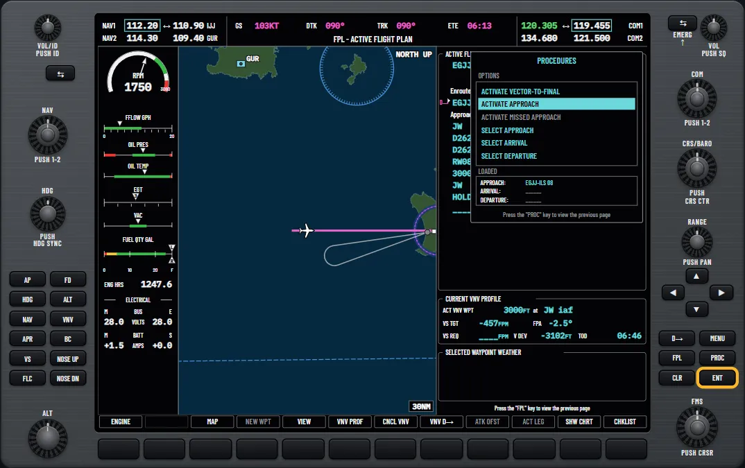
The lessons use two names for one Jersey approach: the list shows RNAV GPS 08 LPV and the chart calls it RNP runway 08. If SBAS or RAIM is unavailable, some published approaches may be missing from the list.
Try it: “Load an approach from the nearest page”: pick Jersey’s RNAV GPS 08 LPV and activate it
You can also pick a GPS approach by the five-digit channel number on its chart. On a cold day, Temperature Compensation in the Active Flight Plan page menu shows a compensated FAF altitude in slanted figures.
Try it: “Approach channel and cold temperatures”: select the RNP 26 at Jersey by its channel number
Integrity and RAIM
The receiver has to trust its position before it can guide you on an approach. SBAS and RAIM both do that job, and only SBAS gives you LPV.
SBAS
Ground stations measure GPS errors, and geostationary satellites broadcast the corrections. On the GPS Status page in the AUX group, SBAS ACTIVE and 3D DIFF NAV mean corrections are in use. The SBAS softkey shows tick boxes for each service: leave them ticked.
RAIM
RAIM (receiver autonomous integrity monitoring) is the receiver checking its own position with spare satellites. It is the fallback when SBAS is unavailable. Its limit on a non-precision approach is 0.3 NM, which is not always met, so run a prediction if SBAS coverage at your destination is in doubt.
On the GPS Status page, push the FMS knob, enter the waypoint, arrival time and date, then press ENT on COMPUTE RAIM? The answer covers 15 minutes either side of that time.
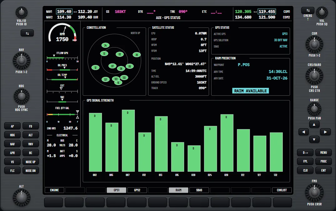
If RAIM is not predicted for the final approach course, the approach will not go active and a yellow LOI (loss of integrity) shows on the HSI. If RAIM is unavailable as you cross the FAF, fly the missed approach.
Try it: “RAIM prediction”: predict RAIM at your present position on the GPS Status page
Try it: “RAIM at a waypoint, and SBAS on and off”: predict RAIM at Jersey, then switch EGNOS off and on
The glidepath
On the HSI, right of the course pointer, the GPS shows the flight phase in magenta. TERM changes to the approach type once the FAF is the active waypoint and you are lined up within 45° of the final course. The course deviation indicator (CDI) tightens from 1 NM full scale, starting 2 NM before the FAF, and narrows like a localiser. A scale tagged G appears left of the altimeter, with a magenta diamond. Fly it as you would a glideslope.
The word on the HSI tells you which minimums apply:
- LPV: LPV minimums, with a glidepath. Needs SBAS.
- L/VNAV: LNAV/VNAV minimums, with a glidepath. Needs SBAS.
- LP: LP minimums, with no glidepath. Needs SBAS.
- LNAV+V: LNAV minimums, with an advisory glidepath only.
- LNAV: LNAV minimums, with no vertical guidance on final.
Try it: “CDI scaling, OBS and SUSP”: see how the flight phase sets the GPS CDI scale
The glidepath uses GPS altitude. Your minimums still come from the altimeter, so set it carefully. If you fly in hectopascals, press the PFD softkey, then ALT UNIT, then HPA.
What a downgrade does
Without SBAS, an LPV approach cannot be added to the active plan, and one already loaded downgrades. The HSI stops reading LPV and the advisory APR DWNGRADE tells you to use LNAV minimums. Past the FAF, NO GP replaces the diamond. An autopilot in GP that loses its data drops to PIT and holds pitch, so take over the descent. Brief the LNAV minimum beforehand, because the decision altitude you set no longer applies.
LOW ALT alerts
LOW ALT belongs to the terrain system. It is a yellow annunciation at the top left of the altimeter that stands in when terrain alerting is switched off. It needs all of these:
- The FAF is the active waypoint of an SBAS GPS approach with vertical guidance.
- You are at least 164 ft below the published FAF altitude.
- TAWS (the terrain awareness and warning system) is inhibited. The terrain alerting that comes with synthetic vision can also be unavailable or failed.
It flashes for several seconds, then stays until you climb back. It checks one altitude at one fix, so it does not watch the glidepath. With TAWS working you will not see it: the premature descent alert watches for you being well below the normal path instead. Inhibit TAWS only for a good reason.
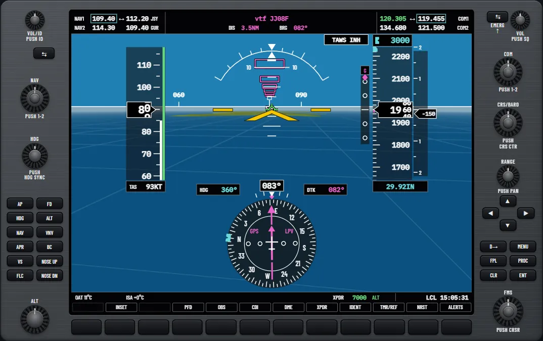
Try it: “LOW ALT on a GPS approach”: inhibit TAWS on the RNP 08 at Jersey and sink below the FAF altitude
Flying it coupled
The autopilot flies an LPV with the same APR key as an ILS on the G1000. The autopilot modes guide explains the modes.
- Press the CDI softkey until the HSI shows GPS, with the approach active. The active waypoint must be part of the plan.
- When cleared, press APR. GPS shows in green for the approach and GP in white, which means the glidepath is armed.
- GP goes green and flashes on capture, and the descent starts. Capture needs the FAF or a later waypoint active, the CDI inside full scale and no SUSP on the HSI.
- At the decision altitude, press AP DISC and land, or press the go-around switch.
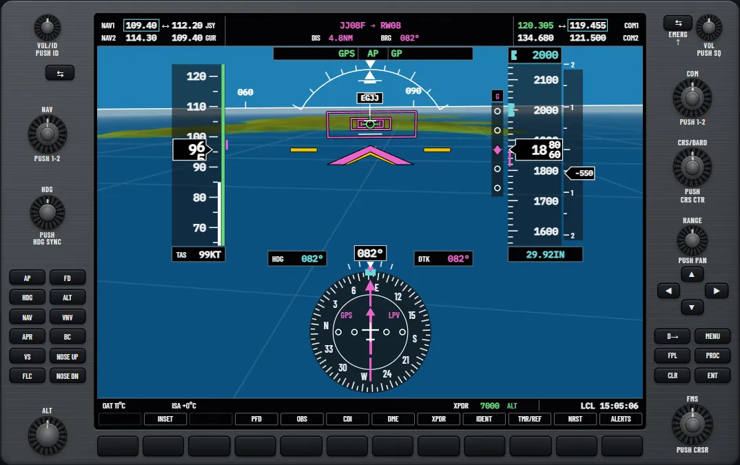
Going around
The go-around switch disconnects the autopilot, sets go-around pitch on the flight director and starts the missed approach. If you disconnect and climb by hand instead, sequencing stops past the missed approach point and the OBS softkey reads SUSP. Press it to carry on, and the HSI changes to MAPR. For GPS loss, see the failures guide.
Try it: “Example flight: approach and missed”: fly the RNP 08 to the LPV decision altitude and go around
All of these lessons are free in the glass cockpit trainer for the G1000, so you can learn the sequence before you pay for time in the aircraft.
Questions pilots ask
- What does LPV stand for?
- Localiser performance with vertical guidance. It is an RNAV approach type flown on SBAS-corrected GPS down to a decision altitude.
- Does an LPV approach need SBAS?
- Yes. That means WAAS in the US and EGNOS in Europe. Without SBAS the approach downgrades and you use the LNAV minimums.
- What does LNAV+V mean on the HSI?
- LNAV minimums with an advisory glidepath. You still fly to the minimum descent altitude and level off there yourself.
- What does RAIM stand for?
- Receiver autonomous integrity monitoring. The GPS receiver uses spare satellites to check its own position.
- What does NO GP mean on the PFD?
- The approach type has downgraded past the final approach fix, so there is no glidepath to follow. It replaces the magenta diamond.
- What does LOW ALT mean on the PFD?
- You are 164 ft or more below the final approach fix altitude on an SBAS approach with vertical guidance, with terrain alerting inhibited. Climb back to that altitude.
See it for yourself
Free and interactive, in your browser. No sign-up, nothing to install.
Sources and further reading
- FAA: Aeronautical Information Manual, Chapter 1 Section 1 (GPS, RAIM and WAAS)
- FAA: Instrument Procedures Handbook
- FAA: Advanced Avionics Handbook (FAA-H-8083-6)
- OPSGROUP: UK, no more LPV approaches after June (2021)
A teaching aid, not an operating manual: the aircraft's flight manual, the published procedures and your instructor come first.
Unofficial training aid. Not affiliated with or endorsed by Garmin. Not for flight: always follow the approved pilot's guide and your instructor. Garmin and G1000 are trademarks of Garmin Ltd. or its subsidiaries.